Cerro Catedral, Argentina Webcamera
November 22, 2015
Cerro Catedral is a mountain located 12 miles from San Carlos de Bariloche, and inside the Nahuel Huapí National Park, Patagonia, Argentina.
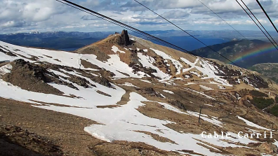
The mountain holds one of the biggest ski centers in South America, with 75 milesof ski runs, and a lift capacity of 35,000 skiers per hour. Cerro Catedral has the highest frequency of days with snowfalls in Argentina, averaging 98 days per year. It is also very popular due to the magnificent view of the Nahuel Huapi lake.
Lake Nahuel Huapi is the largest and deepest clear water lake in the lake district of Argentina, with a depth of 1,394 ft. The lake was discovered by the Jesuit priest Nicolás Mascardi in 1670 who also built a chapel on the Huemul Peninsula of the lake. The lake extends 72 miles across the border with Chile, and includes many fjords and the Valdivian temperate rain forest.
Nahuel Huapi lake was known to Spaniards since the times of the Conquest of Chile. In the summer of 1552–1553, the Governor of Chile Pedro de Valdivia sent Francisco de Villagra to explore the area east of the Andes at the latitudes of the city of Valdivia. Francisco de Villagra crossed the Andes trough Mamuil Malal Pass and headed south until reaching Limay River in the vicinity of Nahuel Huapi Lake.
ViK i Sogn, Norway Webcamera
October 14, 2015
Vik is a municipality in Sogn og Fjordane county, Norway.

The farms in Vik lie on old marine terraces, and many of the burial mounds lie on the edges of these. The Hove mounds were built about 400-500 AD. At Hopperstad, finds have been made that prove Viking raids from Vik. These finds are bronze bowls and bronze dishes, things that probably found their way to Norway with the Viking raids.
In the latter half of the 12th century the Hopperstad Stave Church was built at Hopperstad and the stone Hove Church was built at Hove. The Stave churches are constructions of high quality, richly decorated with carvings. In virtually all of them the door frames are decorated from top to bottom with carvings. This tradition of rich ornamentation appears to go back to the animal carvings of the Viking Age. The dragons are lovingly executed and transformed into long-limbed creatures of fantasy, here and there entwined with tendrils of vine, with winding stems and serrated leaves. The elaborate designs are executed with supreme artistic skill. The stave church doorways are, therefore, among the most distinctive works of art to be found in Norway. However, it is difficult to connect them with the Christian gospel. The Hopperstad stave church was saved from demolition on the initiative of the architect Peter Andreas Blix.
The “West Norwegian Fjords of Geirangerfjord and Nærøyfjord” were added to UNESCO’s World Heritage List in 2005. The two fjords are situated 120 kilometres (75 mi) from each other and they are separated by the Jostedalsbreen glacier.
Tuli Block, Botswana
March 15, 2015
The Tuli Block is a narrow fringe of land at Botswana‘s eastern border wedged between Zimbabwe in the north and east and South Africa in the south

Tuli Block consists mainly of privately owned game farms offering safari tourism. The eastern section up to and including Redshield has been declared a game reserve, known as the Northern Tuli Game Reserve.
The Tuli Block is quite different from anywhere else in Botswana. It is referred to as the Hardveld because of the rocky outcrops and the abundance of stones and pebbles of all shapes and sizes. The red sand of the Tuli area is an unforgettable trait, as well as the massive trees that occur along the banks of the Limpopo.
Much of the area is unfenced allowing the animals to roam freely between the Motloutse and Limpopo rivers. The vegetation is spectacular, the scenery diverse. Gigantic Nyala trees and the yellow barked fever trees grow along the riverbanks. Gaunt sesame trees take root in rocky outcrops. Characteristic baobab trees are ubiquitous amongst the rock koppies. Animals flourish in the wild terrain.
Wildebeest, kudu, eland, impala and waterbuck migrate through the area. Lions (some of them black maned), leopard and cheetah follow the game and mingle with the large herds of elephants. Nile crocodile abound in large pools in the Limpopo River, with the occasional hippopotamus. Bird life proliferates in the diverse environment. Different kinds of kingfishers dart into the streams and rivers, while waders stand in the shallows. The rare Pel’s Fishing Owl frequents banks above large pools in rivers, best seen at night.
Casa Bonita, Bonaire Webcamera
August 3, 2014
Bonaire is a Caribbean island located off the coast of South America near the western part of Venezuela.

The name Bonaire is thought to have originally come from the Caquetio word ‘Bonay’. The early Spanish and Dutch modified its spelling to Bojnaj and also Bonaire, which means “Good Air”. Bonaire was part of the Netherlands Antilles until the country’s dissolution on 10 October 2010, when the island became a special municipality within the country of the Netherlands.
Bonaire’s earliest known inhabitants were the Caquetio Indians, a branch of the Arawak who came by canoe from Venezuela in about 1000 AD. Archeological remains of Caquetio culture have been found at certain sites northeast of Kralendijk and near Lac Bay. Caquetio rock paintings and petroglyphs have been preserved in caves at Spelonk, Onima, Ceru Pungi, and Ceru Crita-Cabai. The Caquetios were apparently a very tall people, for the Spanish name for the ABC Islands was ‘las Islas de los Gigantes’ or ‘the islands of the giants.
Bonaire is also famed for its flamingo populations and its donkey sanctuary. Flamingos are drawn to the brackish water, which harbours the shrimp upon which they feed. Starting in the 16th century, the Dutch raised sheep, goats, pigs, horses and donkeys on Bonaire, and the descendants of the goats and donkeys roam the island today, with a small population of pigs roaming as well.
At Casa Bonita every day they faithfully put out sugar and fresh water for their fine feathered friends. this draws droves of little bananaquits, called chibichibis in Papiamento and suikerdief in Dutch.
Perros-Guirec, France Webcamera
February 16, 2014
Perros-Guirec is a commune in the Côtes-d’Armor department in Brittany in northwestern France.

Perros-Guirec is a popular seaside resort, with beaches and opportunities for water and beach sports. It is also known for its pink granite rocks which have been sculpted by the sea into varied shapes and patterns. There are three large sandy beaches suitable for families. Plage Trestraou is popular for swimming and sunbathing, as it is sheltered and receives full sunshine. The Plage Trestrignel is wilder and more exposed to the wind.
The nearby Grand Isle, separated from the mainland by a narrow channel, was once famous for its granite quarrying industry. The rock was transported from the island by boat, and was used in the construction of many imposing buildings in Paris.
The Ploumanac’h lighthouse, is an active lighthouse in Côtes-d’Armor, France, located in Perros-Guirec. The first Ploumanac’h lighthouse dates from 1860. This was destroyed in 1944, and replaced by the current lighthouse in 1946. The present-day version was planned by architect Henry Auffret, and built by Martin et frère (a local construction company). The lighthouse gets its common name from the nearby town of Ploumanac’h, meaning “church of the monks” in Breton. The official name of “Mean Ruz” comes from the Breton cacographic phrase Men Ruz, meaning “red stone”. The lighthouse offers a direct view of château de Costaérès, l’île Renote and Jentilez.
Joseph Conrad lived here for several years and wrote many of his most famous maritime books during that period.
Shinmoedake, Japan Webcam
March 13, 2011
Shinmoedake is a volcano in Kyūshū, Japan, and a part of the Mount Kirishima cluster of volcanoes. It is believed to have formed between 7,300 and 25,000 years ago.

The 2011 eruptions began on 19 January. On 26 January, at 7:30 AM, increased eruption activity spewed ash over the surrounding area. The ash closed four railroad lines, and some airline service was cancelled due to heavy smoke. It was the largest eruption from Shinmoedake since 1959. On 1 February, an even larger eruption sent smoke up to 2.5 km in the air and threw volcanic bombs up to 1.5 km.
During February 2011, a lava dome formed in Shinmoedake’s crater. On February 17, an evacuation advisory was put in place for the Miyakonojo area for 2,500 people after heavy rains threatened to produce lahars.
On 13 March, the volcano once again erupted two days after the 2011 Sendai Earthquake. Whether the cause of the eruption is related to the earthquake, or whether the initial January eruption and the earthquake shared a common cause is still unknown.
(The webcam map is in Japanese. In the menu on the right, Kirishima is the 7th from the bottom of the list)
Korat, Thailand Webcam
April 9, 2010
Korat is Thailand’s largest province and the ‘Gateway to Isaan’ . It also has beautiful National Parks, with many forests, mountains, waterfalls, and reservoirs.

The province is located on the western end of the Khorat Plateau, separated from the Chao Phraya river valley by the Phetchabun and Dong Phaya Yen mountain ranges. The area around Korat was already an important center in the times of the Khmer empire in the 11th century, as can be seen by the temple ruins in the Phimai historical park.
At present, this area has a collection of over 10,000 petrified wood pieces. Some are displayed in the garden. Within this compound, petrified wood was unearthed just beneath the surface to 8 metres underground. The wood discovered is of various sizes from pebbles to rocks are aged from 1 to 70 million years old.
The Korat is one of the oldest stable cat breeds. Originating in Thailand, it is named after the Nakhon Ratchasima province (“Korat” by the Thai people). In Thailand it is known as Si-Sawat, meaning “Color of the Sawat Seed”. They are known colloquially as the “Good Luck Cat” and are given in pairs to newlyweds for good luck. Until recently, Korats were not sold, but only given as gifts.
Soppong, Thailand Camera
October 11, 2008
Mae Hong Son (The City of Three Mists) is nestled in a deep valley hemmed in by high mountain ranges. Mae Hong Son has long been isolated from the outside world and is the most mountainous province in Thailand. Most of the areas are complex mountain ranges and likely still pristine virgin forest.

The name refers to the fact that this terrain is highly suitable for the training of elephants. Former governors of Chiang Mai used to organize the rounding up of wild elephants which were then trained to work in the capital.
Several prehistoric sites are known within Pang Mapha area. The most famous one is the Spirit Cave occupied from about 9000 till 5500 BC by Hoabinhian hunters and gatherers.
Keep in mind, this is a very remote area. The webcam is not always on, but it is well worth the wait.


