ViK i Sogn, Norway Webcamera
October 14, 2015
Vik is a municipality in Sogn og Fjordane county, Norway.

The farms in Vik lie on old marine terraces, and many of the burial mounds lie on the edges of these. The Hove mounds were built about 400-500 AD. At Hopperstad, finds have been made that prove Viking raids from Vik. These finds are bronze bowls and bronze dishes, things that probably found their way to Norway with the Viking raids.
In the latter half of the 12th century the Hopperstad Stave Church was built at Hopperstad and the stone Hove Church was built at Hove. The Stave churches are constructions of high quality, richly decorated with carvings. In virtually all of them the door frames are decorated from top to bottom with carvings. This tradition of rich ornamentation appears to go back to the animal carvings of the Viking Age. The dragons are lovingly executed and transformed into long-limbed creatures of fantasy, here and there entwined with tendrils of vine, with winding stems and serrated leaves. The elaborate designs are executed with supreme artistic skill. The stave church doorways are, therefore, among the most distinctive works of art to be found in Norway. However, it is difficult to connect them with the Christian gospel. The Hopperstad stave church was saved from demolition on the initiative of the architect Peter Andreas Blix.
The “West Norwegian Fjords of Geirangerfjord and Nærøyfjord” were added to UNESCO’s World Heritage List in 2005. The two fjords are situated 120 kilometres (75 mi) from each other and they are separated by the Jostedalsbreen glacier.
Porto, Portugal Webcamera
September 6, 2015
Porto is the second-largest city in Portugal, after Lisbon.
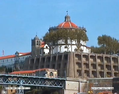
Porto is one of the oldest European centres, and its historical core was proclaimed a World Heritage Site by UNESCO in 1996. The western part of its urban area extends to the coastline of the Atlantic Ocean. Its settlement dates back many centuries, when it was an outpost of the Roman Empire. Its combined Celtic–Latin name, Portus Cale, has been referred to as the origin of the name “Portugal”, based on transliteration and oral evolution from Latin.
The history of Porto dates back to around 300 BC with Proto-Celtic and Celtic people being the first known inhabitants. Ruins of that period have been discovered in several areas. During the Roman occupation of the Iberian Peninsula the city developed as an important commercial port, primarily in the trade between Olissipona (the modern Lisbon) and Bracara Augusta (the modern Braga).
One of Portugal’s internationally famous exports, port wine, is named for Porto, since the metropolitan area, and in particular the caves of Vila Nova de Gaia, were responsible for the packaging, transport and export of the fortified wine.
Lisbon, Portugal Webcamera
April 26, 2015
Lisbon is the capital and the largest city of Portugal, with a population of 552,700.
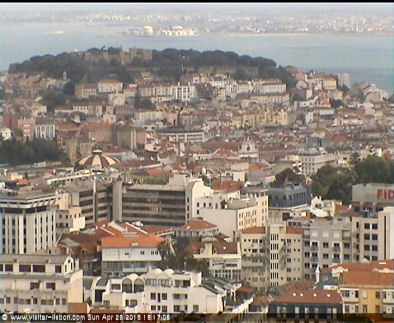
Lisbon is one of the oldest cities in the world, and the oldest in Western Europe, predating other modern European capitals such as London, Paris and Rome by centuries. Julius Caesar made it a municipium called Felicitas Julia, adding to the name Olissipo. Ruled by a series of Germanic tribes from the 5th century, it was captured by the Moors in the 8th century. In 1147, the Crusaders under Afonso Henriques reconquered the city and since then it has been a major political, economic and cultural centre of Portugal.
Most of the Portuguese expeditions of the Age of Discovery left from Lisbon during the 15th to 17th centuries, including Vasco da Gama‘s expedition to India in 1497. In 1506. The 16th century was Lisbon’s golden era: the city was the European hub of commerce between Africa, India, the Far East and later, Brazil, and acquired great riches by exploiting the trade in spices, slaves, sugar, textiles and other goods. This period saw the rise of the exuberant Manueline style in architecture, which left its mark in many 16th century monuments (including Lisbon’s Belém Tower and Jerónimos Monastery, which were declared UNESCO World Heritage Sites). A description of Lisbon in the 16th century was written by Damião de Góis and published in 1554.
Tuli Block, Botswana
March 15, 2015
The Tuli Block is a narrow fringe of land at Botswana‘s eastern border wedged between Zimbabwe in the north and east and South Africa in the south

Tuli Block consists mainly of privately owned game farms offering safari tourism. The eastern section up to and including Redshield has been declared a game reserve, known as the Northern Tuli Game Reserve.
The Tuli Block is quite different from anywhere else in Botswana. It is referred to as the Hardveld because of the rocky outcrops and the abundance of stones and pebbles of all shapes and sizes. The red sand of the Tuli area is an unforgettable trait, as well as the massive trees that occur along the banks of the Limpopo.
Much of the area is unfenced allowing the animals to roam freely between the Motloutse and Limpopo rivers. The vegetation is spectacular, the scenery diverse. Gigantic Nyala trees and the yellow barked fever trees grow along the riverbanks. Gaunt sesame trees take root in rocky outcrops. Characteristic baobab trees are ubiquitous amongst the rock koppies. Animals flourish in the wild terrain.
Wildebeest, kudu, eland, impala and waterbuck migrate through the area. Lions (some of them black maned), leopard and cheetah follow the game and mingle with the large herds of elephants. Nile crocodile abound in large pools in the Limpopo River, with the occasional hippopotamus. Bird life proliferates in the diverse environment. Different kinds of kingfishers dart into the streams and rivers, while waders stand in the shallows. The rare Pel’s Fishing Owl frequents banks above large pools in rivers, best seen at night.
2014 in review
December 29, 2014
The WordPress.com stats helper monkeys prepared a 2014 annual report for this blog.

Here's an excerpt:
A San Francisco cable car holds 60 people. This blog was viewed about 1,300 times in 2014. If it were a cable car, it would take about 22 trips to carry that many people.
Aizu-Wakamatsu Station, Fukushima, Japan Webcamera
November 29, 2014
Aizu-Wakamatsu Station is a railway station in Aizuwakamatsu, in Fukushima Prefecture, Japan.

The train operation is divided at Aizu-Tajima Station. The electrified southern part has through service beyond the Aizukōgen-Ozeguchi terminus onto the Yagan Railway Aizu Kinugawa Line, Tobu Railway and JR East all the way to Tokyo. The non-electrified northern part runs diesel service beyond Nishi-Wakamatsu Station to Aizu-Wakamatsu Station on the JR East Tadami Line.
On Friday, 11 March 2011, 14:46 JST, a magnitude 9.0 earthquake occurred off the coast of Miyagi Prefecture. Shindo measurements throughout the prefecture reached as high as 6-upper in isolated regions of Hama-dōri on the eastern coast and as low as a 2 in portions of the Aizu region in the western part of the prefecture. Fukushima City, located in Naka-dōri and the capital of Fukushima Prefecture, measured 6-lower.
Train services were stopped due to damage caused to railway infrastructure. The Iizaka Line reopened two days later on March 13, and on March 31 the Yamagata Shinkansen resumed limited service and the Ōu Main Line resumed full service. By April 7 the Tōhoku Main Line was reopened in both directions, however it was closed again following a strong earthquake later that night. The Tōhoku Main Line was again reopened in both directions from Fukushima on April 17. The Tōhoku Shinkansen reopened with limited service on April 23, and the Abukuma Express Line resumed limited service from Fukushima on April 28. Aizu-Wakamatsu Station Video
Kleine Scheidegg, Switzerland Webcamera
November 29, 2014
Kleine Scheidegg is a high mountain pass below and between the Eiger and Lauberhorn peaks in the Bernese Oberland, Switzerland.

Located at Kleine Scheidegg is the Hotel Bellevue des Alpes and the Kleine Scheidegg railway station, which serves the two rack railways, the Wengernalpbahn (since 1893) and the Jungfraubahn (since 1896). The Wengernalpbahn has two branches: one begins at Grindelwald; the other commences at Lauterbrunnen and climbs to the pass via Wengen. The Jungfraubahn climbs steeply through tunnels inside the Eiger and Mönch mountains up to its terminal at the Jungfraujoch.
There is a tradition in the Bernese Oberland, supported by some documentary evidence, that a pass existed between Grindelwald and Fiesch in Valais, four or five centuries ago, before the increase of the glaciers blocked it. In modern times the old pass’s precise location is a matter of uncertainty. Since a hotel on the Eggishorn has been frequented by English mountaineers, the possibility of traversing the great ridge that encloses the head of the Aletsch Glacier, and connecting the Eggishorn with Grindelwald and Wengern Alp, has gained interest, and a topographical problem which has excited adventurous mountaineers. The result has been, that no less than four such passes have been effected. Two of the number, the Jungfraujoch and the Eigerjoch, are among the most difficult passes in the Alps
Great Bay, Sint Maarten Webcamera
November 22, 2014
Sint Maarten is a constituent country of the Kingdom of the Netherlands.
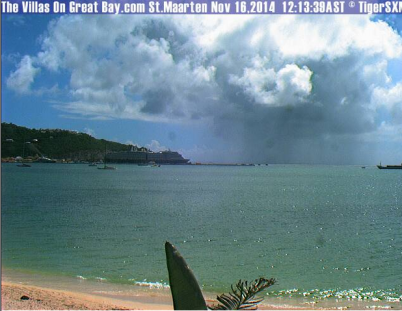
Sint Maarten encompasses the southern third of the Caribbean island of Saint Martin, while the northern two-thirds of the island constitutes the French overseas collectivity of Saint-Martin. Its capital is Philipsburg.
In 1493, during Christopher Columbus‘ second voyage to the West Indies, upon first sighting the island he named it Isla de San Martín after Saint Martin of Tours because it was 11 November, St. Martin’s Day. However, though he claimed it as a Spanish territory, Columbus never landed there, and Spain made the settlement of the island a low priority.
In 1994, the Kingdom of the Netherlands and France signed the Franco-Dutch treaty on Saint Martin border controls, which allows for joint Franco-Dutch border controls on so-called “risk flights”. After some delay, the treaty was ratified in November 2006 in the Netherlands, and subsequently entered into force on 1 August 2007. Though the treaty is now in force, its provisions are not yet implemented as the working group specified in the treaty is not yet installed.
The island is famous for its runway at Princess Juliana International Airport, in which landing aircraft pass within at least 20 feet of Maho Beach below, due to the close proximity of the runway to the ocean. The planes appear to land dangerously close to beach goers. Therefore this beach and airport has become a popular place for people to view airplane landings.


