Musala, Bulgaria Webcamera
January 28, 2014
Musala is the highest peak in Bulgaria and the entire Balkan Peninsula, standing at 2,925 m.
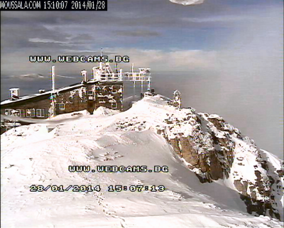
The summit of the Rila mountain in southwestern Bulgaria, Musala is the highest peak between the Alps and the Caucasus and the highest in Eastern Europe bar the Caucasus. Musala is situated within the Rila National Park, which is noted for its rich flora, including species such as Macedonian Pine and Bulgarian Fir in the forests on its middle slopes, and fauna; it is one of the easiest places in Europe to see the wallcreeper. All major mountain ranges of Bulgaria can be seen from the top; these include Vitosha to the northwest, Sredna Gora towards the northeast, the Balkan Mountains along most of the northern horizon behind Vitosha and Sredna Gora, the Rhodope Mountains to the southeast, Pirin to the south, Osogovo and Ruy Mountain to the west, and of course Rila.
With an average annual temperature of -3 °C Musala is the coldest place in Bulgaria and the entire Balkan Peninsula. Temperatures stay below 0 °C for about 8 months each year. Due to this about 45% of the annual precipitation on Musala is snow, and snow cover lasts for about 200 days (more than 6,5 months). Three of the main rivers of Bulgaria, the Iskar, Maritsa and Mesta have their sources near Musala.
A cosmic ray study station functioned at the summit until it was devastated by a fire in 1984. The station was re-opened in 1999 as the Environmental Observatory “Musala” of the Bulgarian Academy of Sciences where air pollutants and space radiation are monitored. Also there is a meteorological station, that is doing regular synoptic and climatic observations. The station belongs to the National Institute of Meteorology and Hydrology (NIMH) and functions without breaks since 1933.
San Juan de Pasto, Columbia Webcamera
January 26, 2014
Pasto is the capital of the department of Nariño, located in southwestern Colombia.
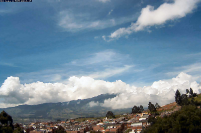
Pasto was originally founded in 1537 by the Spanish conquistador Sebastián de Belalcázar. In 1539 another Spanish conquistador Lorenzo de Aldana moved the city to its current location, and established it under the name “San Juan de Pasto”. Pasto is a reference to the name of the indigenous people who inhabited the region at the arrival of the conquerors, the Pastos. However, the Atriz Valley was inhabited by the Quillacingas. A major contributor to the economy and expansion of Pasto was a man of Italian origin named Guido Bucheli.
Galeras is an Andean stratovolcano near the departmental capital Pasto. Galeras has been an active volcano for at least a million years, with andesite as the dominant product. Two major caldera-forming eruptions have occurred, the first about 560,000 years ago in an eruption which expelled about 15 cubic kilometres of material. The second some time between 40,000 and 150,000 years ago, in a smaller but still sizable eruption of 2 cubic kilometres of material.
A Decade Volcano conference in the city of Pasto, in 1993, ended in disaster when several of the scientists present mounted an impromptu expedition on 14 January to the crater of Galeras. An eruption occurred unexpectedly while they were at the summit, resulting in the deaths of six scientists and three tourists. Elements in the media made the event controversial by suggesting the expedition leader, geologist Stanley Williams, who survived along with four others, had ignored safety procedures.
Sinabung, Indonesia Webcamera
January 21, 2014
Mount Sinabung is a Pleistocene-to-Holocene stratovolcano.
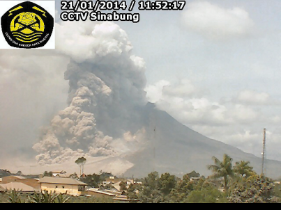
Located in the Karo plateau of North Sumatra, Indonesia, 25 miles from Lake Toba supervolcano, many old lava flows are on its flanks and the last known eruption, before recent times, occurred in the year 1600. Solfataric activities (cracks where steam, gas, and lava are emitted) were last observed at the summit in 1912, other documented events include an eruption in the early hours of 29 August 2010 and eruptions in September and November 2013 and January 2014
Most of Indonesian volcanism stems from the Sunda Arc, created by the subduction of the Indo-Australian Plate under the Eurasian Plate. This arc is bounded on the north-northwest by the Andaman Islands, a chain of basaltic volcanoes, and on the East by the Banda Arc, also created by subduction.
On January 4th 2014 the volcano erupted again. “Mount Sinabung, which has erupted over a hundred times between Jan. 4 through the morning of Jan. 5 is spewing out a 4,000-meter high column of ash damaging property and crops and poisoning animals over a wide radius.
Time lapse:
Castine, Maine Webcamera
January 21, 2014
Castine is a town in Hancock County, Maine, United States and served as the capital of Acadia (1670–1674).
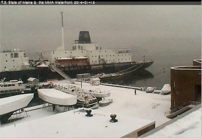
Called Majabigwaduce by Tarrantine Abenaki Indians, Castine is one of the oldest towns in New England, predating the Plymouth Colony by seven years. Situated on Penobscot Bay, it is near the site of Fort Pentagouet. Few places in New England have had a more tumultuous history than Castine—which proclaims itself the “battle line of four nations.”
The Castine peninsula appears on a 1612 chart submitted to King Henry IV of France by Samuel de Champlain, who called it the Pentagoët Peninsula. As part of Henry’s program to defend Acadia, Castine was founded in the winter of 1613, when Claude de Saint-Etienne de la Tour established a small trading post to conduct business with the Tarrantine Indians (now called the Penobscots)
At the end of the French and Indian War, which secured English title to North America, the unoccupied lands along the Maine coast were opened to settlement by Massachusetts colonists. Though the fur trade was long dead, the region’s abundant fisheries and timber attracted entrepreneurs, and the attention of the British government, which was always on the lookout for store to supply its growing navy. Bagaduce was especially valuable for supplying timber suitable for masts on British warships.
Castine is the home of Maine Maritime Academy, a four-year institution that graduates officers and engineers for the United States Merchant Marine and marine related industries.
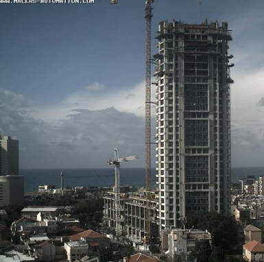
Tel Aviv, Israel Webcamera
January 5, 2014
Tel Aviv is the second most populous city in Israel.
Tel Aviv is an economic hub, home to the Tel Aviv Stock Exchange, corporate offices and research and development centers. It is the country’s financial capital and a major performing arts and business center. Tel Aviv has the second-largest economy in the Middle East after Dubai, and is the 31st most expensive city in the world. It is known as “the city that never sleeps” and a “party capital” due to its lively nightlife, dynamic atmosphere and famous 24-hour culture.
The ancient port of Jaffa changed hands many times in the course of history. Archeological excavations from 1955 to 1974 unearthed towers and gates from the Middle Bronze Age. They also exposed sections of a packed-sandstone glacis and a massive brick wall, dating from the Late Bronze Age, as well as a temple attributed to the Sea Peoples and dwellings from the Iron Age. The city, Jaffa, is first mentioned in letters from 1470 BC that record its conquest by Egyptian Pharaoh Thutmose III.
Bauhaus architecture was introduced in the 1920s and 1930s by German Jewish architects who settled in Palestine after the rise of the Nazis. Tel Aviv’s White City, around the city center, contains more than 5,000 Modernist-style buildings inspired by the Bauhaus school and Le Corbusier.
2013 in review
January 5, 2014
The WordPress.com stats helper monkeys prepared a 2013 annual report for this blog.

Here’s an excerpt:
A San Francisco cable car holds 60 people. This blog was viewed about 2,400 times in 2013. If it were a cable car, it would take about 40 trips to carry that many people.


