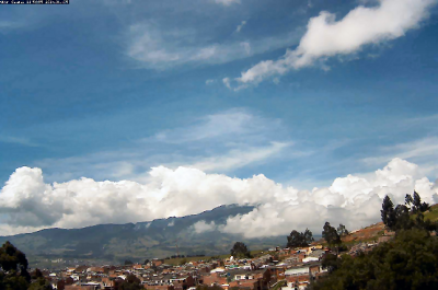
San Juan de Pasto, Columbia Webcamera
January 26, 2014
Pasto is the capital of the department of Nariño, located in southwestern Colombia.
Pasto was originally founded in 1537 by the Spanish conquistador Sebastián de Belalcázar. In 1539 another Spanish conquistador Lorenzo de Aldana moved the city to its current location, and established it under the name “San Juan de Pasto”. Pasto is a reference to the name of the indigenous people who inhabited the region at the arrival of the conquerors, the Pastos. However, the Atriz Valley was inhabited by the Quillacingas. A major contributor to the economy and expansion of Pasto was a man of Italian origin named Guido Bucheli.
Galeras is an Andean stratovolcano near the departmental capital Pasto. Galeras has been an active volcano for at least a million years, with andesite as the dominant product. Two major caldera-forming eruptions have occurred, the first about 560,000 years ago in an eruption which expelled about 15 cubic kilometres of material. The second some time between 40,000 and 150,000 years ago, in a smaller but still sizable eruption of 2 cubic kilometres of material.
A Decade Volcano conference in the city of Pasto, in 1993, ended in disaster when several of the scientists present mounted an impromptu expedition on 14 January to the crater of Galeras. An eruption occurred unexpectedly while they were at the summit, resulting in the deaths of six scientists and three tourists. Elements in the media made the event controversial by suggesting the expedition leader, geologist Stanley Williams, who survived along with four others, had ignored safety procedures.
Sinabung, Indonesia Webcamera
January 21, 2014
Mount Sinabung is a Pleistocene-to-Holocene stratovolcano.
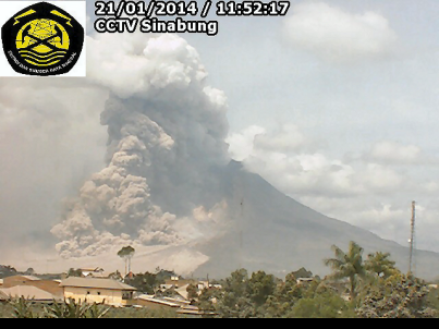
Located in the Karo plateau of North Sumatra, Indonesia, 25 miles from Lake Toba supervolcano, many old lava flows are on its flanks and the last known eruption, before recent times, occurred in the year 1600. Solfataric activities (cracks where steam, gas, and lava are emitted) were last observed at the summit in 1912, other documented events include an eruption in the early hours of 29 August 2010 and eruptions in September and November 2013 and January 2014
Most of Indonesian volcanism stems from the Sunda Arc, created by the subduction of the Indo-Australian Plate under the Eurasian Plate. This arc is bounded on the north-northwest by the Andaman Islands, a chain of basaltic volcanoes, and on the East by the Banda Arc, also created by subduction.
On January 4th 2014 the volcano erupted again. “Mount Sinabung, which has erupted over a hundred times between Jan. 4 through the morning of Jan. 5 is spewing out a 4,000-meter high column of ash damaging property and crops and poisoning animals over a wide radius.
Time lapse:
Shinmoedake, Japan Webcam
March 13, 2011
Shinmoedake is a volcano in Kyūshū, Japan, and a part of the Mount Kirishima cluster of volcanoes. It is believed to have formed between 7,300 and 25,000 years ago.

The 2011 eruptions began on 19 January. On 26 January, at 7:30 AM, increased eruption activity spewed ash over the surrounding area. The ash closed four railroad lines, and some airline service was cancelled due to heavy smoke. It was the largest eruption from Shinmoedake since 1959. On 1 February, an even larger eruption sent smoke up to 2.5 km in the air and threw volcanic bombs up to 1.5 km.
During February 2011, a lava dome formed in Shinmoedake’s crater. On February 17, an evacuation advisory was put in place for the Miyakonojo area for 2,500 people after heavy rains threatened to produce lahars.
On 13 March, the volcano once again erupted two days after the 2011 Sendai Earthquake. Whether the cause of the eruption is related to the earthquake, or whether the initial January eruption and the earthquake shared a common cause is still unknown.
(The webcam map is in Japanese. In the menu on the right, Kirishima is the 7th from the bottom of the list)
Fimmvörðuhálsi, Iceland Webcam
April 2, 2010
Eyjafjallajökull is one of the smaller glaciers of Iceland. It is situated to the north of Skógar and to the west of the larger glacier Mýrdalsjökull.

The name Eyjafjöll usually describes an area of small mountains which form the base of the volcano. This area was once part of the island’s Atlantic coastline. As the sea retreated some 5 km, the former coastline has left behind sheer cliffs with a multitude of beautiful waterfalls, like Skógafoss and Seljalandsfoss. In strong winds, the water of the smaller falls can even be blown up the mountain.
The icecap of the glacier covers a 700.000 year old volcano (1,666 m in height) which has erupted infrequently since the Ice Age. There were only 3 eruptions during the last 1100 years since the settlement of Iceland. The latest eruption began in March 2010, and the second most recent eruption was from 1821 to 1823, causing some smaller glacier runs. Previous eruptions were in 1612 and 920.
Around Christmas 2009, seismic activity began around the Eyjafjallajökull volcano area, with thousands of small earthquakes (mostly magnitude 1–2 on the Richter scale) 7–10 kilometres beneath the volcano.
Mt. Fuji, Japan Webcamera
November 11, 2008
Mount Fuji (富士山)is the highest mountain in Japan at 3,776 m (12,388 ft). Along with Mount Tate and Mount Haku, it is one of Japan’s “Three Holy Mountains”.

Mount Fuji is a frequent subject of Japanese art. Amongst the most renowned works are Hokusai‘s 36 Views of Mount Fuji and his One Hundred Views of Mount Fuji. The mountain is also mentioned in Japanese literature and is the subject of many poems.
The volcano is currently classified as active with a low risk of eruption. The last recorded eruption started on December 16, 1707 and ended about January 1, 1708 during the Edo period. This is sometimes called “the great Hōei eruption.” Fuji spewed cinders and ash which fell like rain in Izu, Kai, Sagami, and Musashi.
Mount Fuji is located at the point where the Eurasian Plate (or the Amurian Plate), the Okhotsk Plate, and the Philippine Plate meet. Those plates form the western part of Japan, the eastern part of Japan, and the Izu Peninsula respectively.
Mt. Ararat, Armenia Cam
November 1, 2008
Mount Ararat with an elevation of almost 17.000 ft is the tallest peak in Turkey. This snow-capped, dormant volcanic cone is located in the Iğdır Province, near the northeast corner of Turkey. Ararat is a stratovolcano, formed of lava flows and pyroclastic ejecta, ; the mountain mostly consists of igneous rocks covered by an ice sheet.

It is not known when the last eruption of Ararat occurred; there are no historic or recent observations of large-scale activity recorded. The last eruption will have occurred somewhere in the last 10000 years. It seems that Ararat was active in the 3rd millennium BC; under the pyroclastic flows, artifacts from the early Bronze Age and remains of human bodies have been found.
According to a legend, a Roman emperor ordered a number of Roman soldiers who converted to Christianity (now called ten thousand martyrs of Mount Ararat) to be crucified on Mount Ararat.
Mount Pelée, Martinique Webcam
September 11, 2008
Mount Pelée (French: Montagne Pelée, or “Bald Mountain”) is a dormant volcano on the northern tip of the French overseas department of Martinique in the Lesser Antilles island arc of the Carribean. It is among the deadliest stratovolcanos on Earth.

Mount Pelée is famous for its extremely destructive eruption in 1902 and the destruction that resulted, now dubbed the worst volcanic disaster of the 20th century. The eruption killed about 30,000 people, most deaths in the destroyed Saint-Pierre, at that time the largest city in Martinique, due to its deadly pyroclastic flows. The eruption left only two survivors in the direct path of the volcano, one alive because he was in a poorly ventilated, dungeon-like jail cell and the other, living on the edge of the city, escaped with severe burns.
Anak Krakatoa Volcano Webcam
April 3, 2008
Krakatoa is a stratovolcano in the Sunda Strait between the islands of Java and Sumatra in Indonesia. It has erupted repeatedly, massively, and with disastrous consequences throughout recorded history.

The best known eruption culminated in a series of massive explosions on August 26–27, 1883, which was among the most violent volcanic events in modern times. With a Volcanic Explosivity Index of 6, it was equivalent to 200 megatons of TNT — about 13,000 times the yield of an Atomic detonation.
The KRAKMON systems consists of a number of geophysical, gas-geochemical and environmental measuring sites on the Krakatau island complex located in the Sunda Strait.
All data are acquired continuously and are transmitted to the Pasauran Observatory (Western Java) via digital radio telemetry. In Pasauran, the data are collected and transmitted to a server in Jakarta Indonesia via VSAT. From here, the data are accessible through internet. Go to the Camera (KM04) link to view the most recent archived images.


