Cerro Catedral, Argentina Webcamera
November 22, 2015
Cerro Catedral is a mountain located 12 miles from San Carlos de Bariloche, and inside the Nahuel Huapí National Park, Patagonia, Argentina.
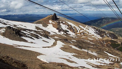
The mountain holds one of the biggest ski centers in South America, with 75 milesof ski runs, and a lift capacity of 35,000 skiers per hour. Cerro Catedral has the highest frequency of days with snowfalls in Argentina, averaging 98 days per year. It is also very popular due to the magnificent view of the Nahuel Huapi lake.
Lake Nahuel Huapi is the largest and deepest clear water lake in the lake district of Argentina, with a depth of 1,394 ft. The lake was discovered by the Jesuit priest Nicolás Mascardi in 1670 who also built a chapel on the Huemul Peninsula of the lake. The lake extends 72 miles across the border with Chile, and includes many fjords and the Valdivian temperate rain forest.
Nahuel Huapi lake was known to Spaniards since the times of the Conquest of Chile. In the summer of 1552–1553, the Governor of Chile Pedro de Valdivia sent Francisco de Villagra to explore the area east of the Andes at the latitudes of the city of Valdivia. Francisco de Villagra crossed the Andes trough Mamuil Malal Pass and headed south until reaching Limay River in the vicinity of Nahuel Huapi Lake.
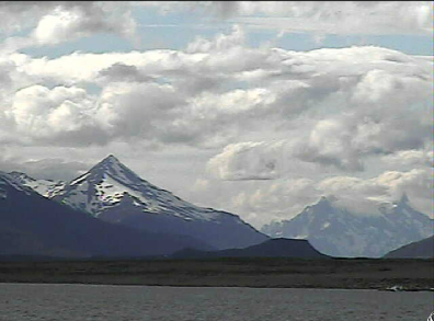
Puerto Natales, Patagonia Webcamera
August 3, 2014
Puerto Natales is a city in Chilean Patagonia.
The province where Puerto Natales is located was named Última Esperanza (Last Hope). It is located at the opening of Última Esperanza Sound and was originally inhabited by the Kawésqar or Alacaluf people and the Aoniken or Tehuelche people. The first European to discover the city was Juan Ladrillero, a sailor who was looking for the Strait of Magellan, in 1557.It was his “last hope” to find the Strait after exploring the maze of channels between the waters of the Pacific and the mainland. It was not until three centuries later, in 1830, that another major expedition sailed through the fjords and channels of Última Esperanza: the British expedition of the sloop HMS Beagle. Some of the expedition – (Robert FitzRoy, William Skyring and James Kirke) and their senior officers – are remembered by several place-names in the area. Commander Fitzroy was the captain during the Second voyage of HMS Beagle (1831–1836).
It is the final passenger port of call for the Navimag ferry sailing from Puerto Montt into the Señoret Channel as well as the primary transit point for travellers to Torres del Paine National Park, Chile.
In 1870, interest in the region of Ultima Esperanza was rekindled. Among the daring travelers who ventured to these desolate lands was Santiago Zamora, also known as ‘Baqueano’ Zamora. He discovered the lakes of the Torres del Paine area and many wild horses are locally known as baguales. Another was the English traveler and writer Lady Florence Dixie, commemorated in the city’s present-day Hotel Lady Florence Dixie. Dixie wrote the book, Across Patagonia.
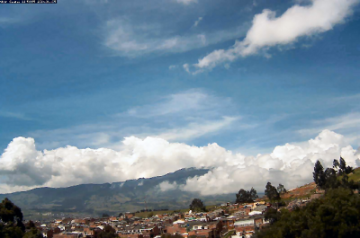
San Juan de Pasto, Columbia Webcamera
January 26, 2014
Pasto is the capital of the department of Nariño, located in southwestern Colombia.
Pasto was originally founded in 1537 by the Spanish conquistador Sebastián de Belalcázar. In 1539 another Spanish conquistador Lorenzo de Aldana moved the city to its current location, and established it under the name “San Juan de Pasto”. Pasto is a reference to the name of the indigenous people who inhabited the region at the arrival of the conquerors, the Pastos. However, the Atriz Valley was inhabited by the Quillacingas. A major contributor to the economy and expansion of Pasto was a man of Italian origin named Guido Bucheli.
Galeras is an Andean stratovolcano near the departmental capital Pasto. Galeras has been an active volcano for at least a million years, with andesite as the dominant product. Two major caldera-forming eruptions have occurred, the first about 560,000 years ago in an eruption which expelled about 15 cubic kilometres of material. The second some time between 40,000 and 150,000 years ago, in a smaller but still sizable eruption of 2 cubic kilometres of material.
A Decade Volcano conference in the city of Pasto, in 1993, ended in disaster when several of the scientists present mounted an impromptu expedition on 14 January to the crater of Galeras. An eruption occurred unexpectedly while they were at the summit, resulting in the deaths of six scientists and three tourists. Elements in the media made the event controversial by suggesting the expedition leader, geologist Stanley Williams, who survived along with four others, had ignored safety procedures.
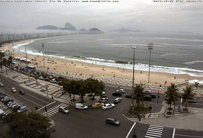
Rio de Janeiro, Brazil Webcamera
December 2, 2013
Rio de Janeiro is the capital city of the State of Rio de Janeiro, the second largest city of Brazil, and the third largest metropolitan area and agglomeration in South America.
Founded in 1565, by the Portuguese, the city was initially the seat of the Captaincy of Rio de Janeiro, a captaincy of the Portuguese Empire. It later, in 1793, became the capital of the State of Brazil, a State of the Portuguese Empire. The city of Rio de Janeiro proper was founded by the Portuguese on March 1, 1565 and was named São Sebastião do Rio de Janeiro, in honor of St. Sebastian, the saint who was the namesake and patron of the then Portuguese Monarch D. Sebastião. Rio de Janeiro was the name of Guanabara Bay. Until early in the 18th century, the city was threatened or invaded by several, mostly French, pirates and buccaneers, such as Jean-François Duclerc and René Duguay-Trouin.
Rio has a tropical savannah climate (Aw ) that closely borders a tropical monsoon climate (Am ), and is often characterized by long periods of heavy rain from December to March. Along the coast, the breeze, blowing alternately onshore and offshore, moderates the temperature. Because of its geographic situation, the city is often reached, especially during autumn and winter, by cold fronts advancing from Antarctica, causing frequent weather changes. It is mostly in summer that strong showers provoke catastrophic floods and landslides. The mountainous areas register greater rainfall since they constitute a barrier to the humid wind that comes from the Atlantic.
The neighbourhood of Copacabana beach hosts one of the world’s most spectacular New Year’s Eve parties (“Reveillon”), as more than two million revelers crowd onto the sands to watch the fireworks display. As of 2001, the fireworks have been launched from boats, to improve the safety of the event.
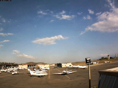
Aeropuerto Caracas Webcam
February 16, 2013
Caracas is the capital and largest city of Venezuela; natives or residents are known as Caraqueños.
Caracas is located in the northern part of the country, following the contours of the narrow Caracas Valley on the Venezuelan coastal mountain range. In 1577 Caracas became the capital of the Spanish Empire’s Venezuela Province under Governor Juan de Pimentel (1576–1583).
During the 17th century, the coast of Venezuela was frequently raided by pirates. With the coastal mountains as a barrier, Caracas was relatively immune to such attacks – one of the reasons it became the principal city of the region. However, in the 1680s, buccaneers crossed the mountains through a little-used pass while the town’s defenders were guarding the more often-used one, and, encountering little resistance, sacked and set fire to the town.
Under the Köppen climate classification, Caracas has a Tropical savanna climate. Hail storms appear in Caracas, although only on rare occasions. Electrical storms are much more frequent, especially between June and October, due to the city being in a closed valley and the orographic action of Cerro El Ávila.
Falkland Islands Webcameras
January 30, 2011
The Falkland Islands are an archipelago in the South Atlantic Ocean, located approximately 250 nautical miles from the coast of mainland South America.

Surrounded by cool South Atlantic waters, the Falkland Islands have a Maritime Subarctic climate. Gales are very frequent, particularly in winter. The climate is similar to that of the Shetland islands in the United Kingdom, but with less rainfall and longer and slightly more severe winters.
The islands were uninhabited when they were first discovered by European explorers, but there is evidence that Patagonian Indians may have reached the Falklands in canoes. Arrowheads and the remains of a canoe have been found on the islands. There was also the presence of the Falkland Island fox, or Warrah (now extinct), but warrahs may have reached the islands via a land bridge when the sea level was much lower during the last ice age.
The Falkland Islands have two airports with paved runways. The British Antarctic Survey operates a transcontinental air link between the Falkland Islands and the Rothera Research Station on the Antarctic Peninsula and servicing also other British bases in the British Antarctic Territory using a de Havilland Canada Dash 7. The Royal Air Force operates flights to Oxfordshire, England, with a refuelling stop at RAF Ascension Island.


